By Ed McMackin, a biologist by training and a naturalist by nature
In its initial years, the Creston Community Forest was committed to several goals, among which was to return into the community a major part of its profits. That was a difficult goal to meet in its beginning years, but now the tables have turned, as the Creston Community Forest has grown and been allotted more timberland, profits have increased, and now recreational aspects of the Kootenay Lake and Creston area are benefiting from a fresh supply of support and funding.
Not only have existing trails been improved and new trails opened up, but there are enhancements including kiosks with descriptive maps, benches, picnic tables, and sturdy bridges. Signs along the trails also display information on the natural history of the area. Trails are alsocleared each spring, maintained, and regularly checked on as quickly as possible after storms. Many of the local trails pass through varying terrain including forest cover, below cliffs and scree slopes, and through other natural landscapes and terrain.
Now let’s head up the Pack Trail.
This trail was thought to have been constructed in the early 1930s for access to early fire-watch locations that, at first, were replete with only tents. around the turn of the century, fire towers were constructed when the government financed the construction of trails for prospecting and mining purposes. A minimum four-foot-wide standard, where possible, was maintained to permit passage of horses and mules, loaded on both sides with bags of ore or supplies. In winter, if there was enough snow cover, bags of ore were drug out on the same trails. Trails were an even grade to make them traversable by people as well as animals. Pick and shovel were the main tools and a device like a very wide shovel, pulled by mules or horses, was used to grade and smooth the trail. This piece of “modern” equipment was called a “Fresno scraper”. Two wood handles made using it a little easier. People worked hard in those days!
People hiking or biking along the Pack Trail, pass steadily upward or downward, around nine or so switch-backs, through mixed and coniferous forests, below large scree areas and cliffs and through shrubby cover comprised of mountain maple, mallow nine-bark and ocean spray. Part way up the trail, one can cross over to the Mount. Thompson Forest Service Road (FSR) via the connecting Rotary Trail.
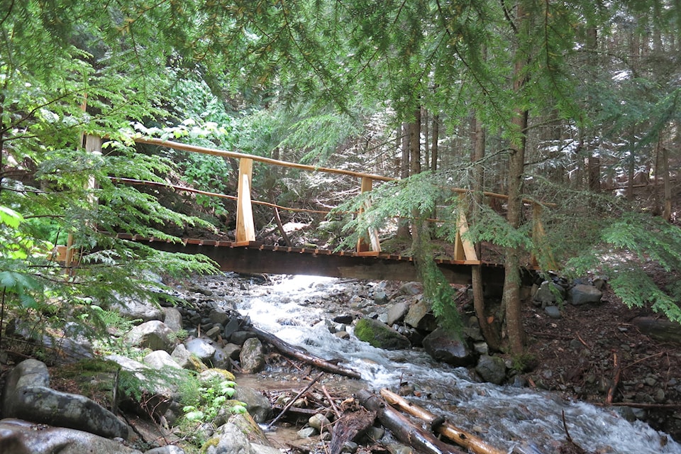
The Pack Trail and the Sullivan Creek Trail both take off, at the same point, from the Mount. Thompson Forest Service Road. The Pack Trail ascends the south aspect slope on the north side of Sullivan Creek. The Sullivan Creek Trail ascends the north facing slope, switch-backing over an old road, constructed in 1948. After three or four hundred meters along the trail, after a re-construction of the natural slope, the trail widens into the old road. Near the start of the trail after the bridge, a damp, shaded area harbors three species of fern – lady, spiny wood, and oak. Much to my dismay, I have been unable to relocate an old concrete cistern I discovered in the early 1980s. The inside was tapered so that, when it froze, the ice would slide upward releasing pressure that would crack the cistern.
A trail connects the Sullivan Creek Trail with the Pack Trail via a log bridge over Sullivan Creek which also has a bit of interesting history. I believe it was named after a Mr. Sullivan who lived down near the Canyon Dam. Mr. Sullivan, I am told, had several daughters, perhaps four, which made the Sullivan home, an interesting gathering place for community young people. An outdoor fireplace-chimney, I believe, may still stand by the open-air “dance hall” which Mr. Sullivan also built on his property, which made it even more popular. (The site is on private property.)
The West Ridge Trail has two focal points. The first is the old hang-gliding spot, which was closed after two glides had fatal consequences. The viewpoint is furnished with a bench and picnic table and a view of Canyon. You may, from the viewpoint, even spot your house or perhaps your grandmother’s house. Right about now, the flat by the picnic table may become a mariposa meadow for a time, replete with three spot mariposa lilies.
The second focal point is the junction of the trail with the Rim Trail which follows south along the ridge to the highest Peak of the Thompson Range – the South Peak – and, Bonnie Lake below. Of course one can drive or ride to the North Peak and hike from there to the South Peak.
More details, such as distances, may be seen on the information boards at the trail-heads (entrances). There are also information kiosks at the beginning of the Billy Goat Bluffs and the Lady Slipper Trails, also part of the Creston Community Forest Trail System.
Hiking the local trails is an excellent way to help deal with the present pressures of the circumstances we are living in. Remember too that the most effective means, like with the historic smallpox problem, is to practise good sanitation, have a healthy lifestyle, and leave the consequences up to the God of all gods!
When you come prepared to a trail, take it!
READ MORE: Out There: Kootenay Lake and the Land