Sometimes people give me “directions” to some place but for some reason I still have to do some searching. (One of my uncles could take longer to tell me how to get there than it took to get there. He had a story for every crook in the road.) Now, hopefully, if you don’t already know the way to the Lady’s Slipper Trail Head, the following might be of some help. (At least take a lunch, water and a light jacket.)
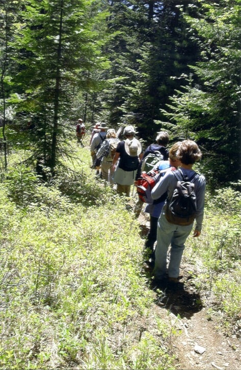
The Lady’s Slipper Trail is on the upper portion of the south slope of Arrow Mountain (a.k.a. Goat Mountain). From Highway 3A to Wynndel from Creston, take the Lakeview-Arrow Creek Road turnoff; after the switchbacks, bear right at the next intersection, pass Wiebe Road, turning right on Foster Road. At the turnaround, where there is some space to park, it connects with the Goat Mountain Forest Service Road. (This point is about 15 minutes from Creston.) From here on, a high clearance vehicle (or mountain bike) is necessary to avoid bottoming out on some of the bumps in the road. In places, the road twists about but generally heads southerly for several kilometres. Keeping more or less to the main drag, keep right at intersections. One split has a Lady’s Slipper Trail directional sign. At close to kilometre 5, the road swings easterly reaching kilometre 6 about where there is a short two-ended pullout on the right and then the Lady’s Slipper Trail Head sign on the left.
The trail, in places, is steep (not extremely) and may have some loose sticks or small, loose rock on it, but it is not at all rocky. Excepting for several flatter sections at some spectacular viewpoints (which you won’t want to miss), the trail climbs steadily to the top. Here the view is not as good as at the several locations along the upper portion of the trail, but you will find a very park-like lunch setting and, if you visit in spring or early summer, lots of flowers. During mid-May of this year I saw the most flowers on top that I have ever seen. The top had snow patches of spring beauty interspersed with yellow glacier lilies. This spot is worth visiting spring, summer and fall and, if you are really ambitious, in winter. During spring, summer and fall, the elevation gain is about 1,250 feet. In winter, snow adds several extra feet. It may take a couple of hours to ascend the trail.
The trail winds through several kinds of landscapes where you have a damp cedar forest and mixed forests of mountain maple, ocean spray and willows along with evergreens. Ground cover can be just dried evergreen needles or shrubs such as snowberry, coenothus and soapberry, along with a host of dappled shade-loving plants, like sarsaparilla, fairy bells and false Solomon’s seal. Some open forest and spaces provide good views of the Kootenay River valley from flat tops of off-trail, steep rocky slopes. These spots are drier than much of the trail. In early July you may still find plants like three-spot lily (Calochortus paniculata) and parsleys that bloom in June at lower elevations along with bearberry (kinnikinnick). In July in the shady forest, you may find the June flowers of lower elevations or the flowers of one-sided wintergreen, green -flowered wintergreen (Pyrola) and prince’s pine (pipsissewa).
Some of the fine songsters that may enhance the sound effects along the trail in late June and early July may still be yellow-rumped, orange-crowned, Nashville and Townsend’s warblers. And the finest songsters you may be privileged to hear could be Swainson’s thrush and perhaps a hermit thrush. If it is raining or before 5 a.m., you may get in on a varied thrush. The mountain swallowtail butterfly is at home with the wild parsley species on which they lay one egg per plant. Swallowtails, from lower elevations, like the pale and the tiger, being strong fliers, may grace your view near the top while the mountain swallowtail may occasionally be seen at lower elevations “claiming” responsibility for the brilliantly colored caterpillar on your parsley or carrot or dill top.
Since this may be the last time we visit for the season, it may be useful to have some directions to the Mount Thompson pack trail and Rotary trail connector. From where Whimster Road joins the Mount Thompson Forest Service Road, continue to the left-hand curve just before kilometre 2 where the historic pack trail (what remains of it) starts immediately on the left of the right leg of this little intersection. It is mainly a series of switchbacks evenly graded until it reaches the FSR at about kilometre 5.5. One can return by this excellent trail or by the road. The Rotary connector trail begins on a left-turning switcback at about kilometre 3 on the FSR at a wide turn in the road. On it one can hike over to the pack trail and up or down. A nicely mastered bench is located at one of its viewpoints. It is a steep slope here — enjoy the view but watch your step! Now how about lunch?
Now, if you eat bread and want a good veggie sandwich you must have good bread! If you were to ask me, my advice would be to go for the King’s Bread or go Steady (with) Eddy or Mack’s (out on) Flax! You may find it where they (historically) over-weighted the tea, no?
Celebrate Canada Day by getting out there! Meet you back here in September, if not sooner!
Ed McMackin is a biologist by profession but a naturalist and hiker by nature. He can be reached at 250-866-5747.