It is interesting that, at times, my hearing is very good and at other times my hearing is bad. Recently I did hear, or I read, that one can tell a true gardener by the fact that they also garden in the fall. That might be said of hikers, too. A real hiker doesn’t just hike when he’s got “spring fever”. Here’s a short, easy hike for autumn times that comes with a pleasant drive to boot. It takes you to a grand view.
It all started with a planned campout at the trailhead to Baker Lake at the south end of the Redding Creek Forest Service Road (FSR). But the pretty hike into Baker Lake, on the backside of Akokli Mountain, didn’t happen because we weren’t prepared to navigate a washout about three miles from the trailhead. So, back we went along the FSR to Gray Creek Pass road and ultimately to the pass. After checking out the primitive campsites, we chose to pitch the tent just off the side of the pullout right at the pass. A potentially interesting trail, which I learned earlier went somewhere, took off, north, right from the pass. The next morning, after a good night and a good feed of huckleberries, we headed on this new adventure.
The trail went northerly along a rounded ridge with not much elevation gain but with lots of open forest. Gray Creek Pass has an elevation of about 6,800 feet so it doesn’t take much to get up to the height-of-land and a grand view.
The well-worn trail leads to the east slope of North Knob, where there are a few ribbons marking a route to a gentle saddle where you can look to the north and take in a spectacular view down some stiff steeps into a basin and also northerly towards Sphinx Mountain, a sample of what you see from the top. I dubbed the little peak, visible to the northwest from the pass, North Knob for lack of a better and/or official name. It is not much of a knob but more of a rounded peak, but it does stand out from the rest of the terrain.
From the saddle, where the landscape is all very open, just look up to the west and that’s how you get to the top. When you reach it you will likely say, “Nothing to it.” There is one important aspect, though, that every hiker should remember, and that is to take careful note of the surroundings and landmarks as you go in so that on the way out you take the same route out, whereas, in this case, you might cut down too early and end up doing a lot of bushwhacking and end up on the road below the pass. For the average hiker this hike could be done in under an hour and a half, and for the less than average hiker it might take another 15 minutes. Some could do it in an hour.
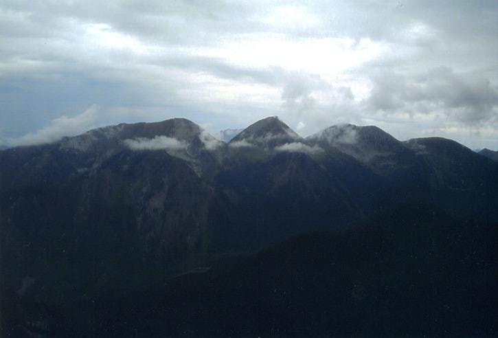
There are many aspects that make the hike to North Knob interesting and pleasant. But, for me, some aspects stood out more than others, even including the huckleberries. I liked the view as it gave me an opportunity to see more of how some familiar mountains and connecting valleys related to each other. To the north is Sphinx Mountain (over 8,300 feet) with Little Sphinx to its left, or west, and Campion Ridge on the east with Campion Plateau, an arctic-alpine splendour, just over a bit more. If you were nearsighted you would think you were on the Arctic tundra. From North Knob you can have them all in a row, on camera, of course.
Kootenay Lake and the West Arm are visible, on a clear day, to the north and west. Off to the south, the snowy chutes of the backside of jagged Akokli Mountain stand out from other mountains. And, then, one of the higher heights of the Purcell Mountains, Snow Crest Mountain, can be located to the southeast, a huge mountain with two tops. If I were to tell you more you might not need to go to North Knob.
Some might say it is too far to drive to get to Gray Creek Pass. You be the judge. Of the many times I have been into the pass this summer, I have never been bored with the drive along Kootenay Lake. It takes about 45 minutes to get to Gray Creek and another half hour to get to the pass. They say the pass is open; however, I recommend a higher-than-average-clearance vehicle than the standard car, especially if you intend to travel on over the pass to Marysville and Kimberley. It’s a gravel road with several shallow water bars higher up toward the pass, which may be hard to see in the morning light. On the east side, lower down, a washout has been repaired but with some rough rock leaving an uneven surface.
With the under-two-hour trip to the pass and under two hour hike to North Knob, it would be a nice day’s outing. Don’t forget the lunch because there may not be any huckleberries left. Go before it snows and the Gray Creek Pass road is closed. Watch out for early morning frost on the steeper section to the top and give it your best foot!
Ed McMackin is a biologist by profession but a naturalist and hiker by nature. He can be reached at 250-866-5747.