Being a warm morning and with a predicted high of 27 C, an East Shore hiking group, at about 9:15, decided to access the Creston Mountain Trail from the Fern Forest Trail rather than from the Balancing Rock Trail. The Fern Forest Trail starts from the Highway 3 bridge over Summit Creek just around the corner from Summit Creek “park” pullout. This choice of route passes through a cool, forested, north-facing slope of Creston Mountain and along the swamp to the boardwalk where it meets the junction of the Balancing Rock and Creston Mountain trails.
The swamp was well “forested” with brilliant yellow flower spathes of skunk cabbage backed by giant, fresh green leaves interspersed with soon-to-be six-foot fronds of the graceful lady fern. I am told that the skunk cabbage has the largest leaves of any plant in North America.
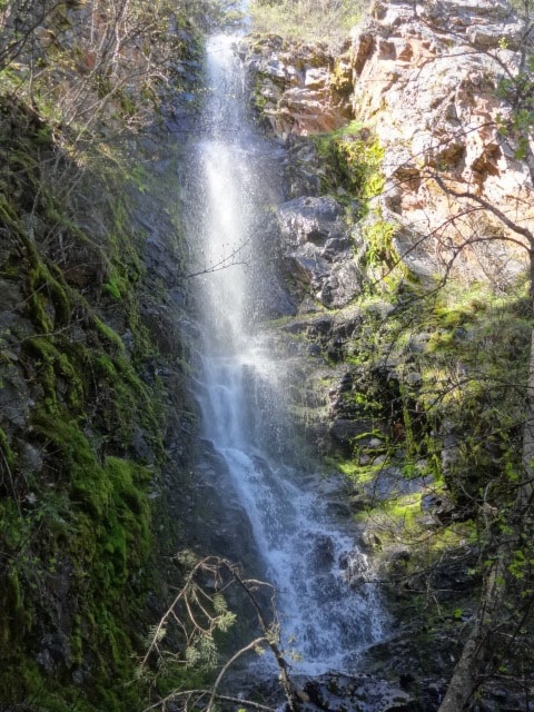
Taking on a moderate gait, we passed over the swamp on a solid boardwalk restored by the Creston Rotary Club and volunteers. We reached the first trailside overlook (approximately 2,600 feet) at about 10:45. The next main stop, other than a few pauses to “smell the flowers”, was the junction of the Holly Falls Trail (a plant namesake) where there is another overlook. Branching to the right at the sign (you have to look up to see the sign) we reached the falls after a five-minute or less walk along an easy trail. We left the, I would guess, 100-foot falls at about 11:15.
We are having a very dry and unseasonably warm spring. When I am out, I see signs of that in the early appearance of flowers and in the early drying of mosses, where they almost crunch underfoot. A couple of weeks ago, I thought the little brook that runs over the trail below Holly Falls was already dried up, but the brook was running over the trail a week or two later. In trying to understand this reverse phenomenon I concluded that snowmelt, from away up on the mountain slopes, with our recent warm weather, was increasing the flow to that of more usual seasons.
 At 12:15 we reached the “End of Trail” (about 3,800 feet) and the rock outcropping where we lunched and enjoyed the view. At that overlook, we also snooped out three ferns growing among the rocks: parsley, woodsia and lace ferns.
At 3:15, we were at the Balancing Rock Trail trailhead where a shuttle vehicle was left. We had planned to descend the Balancing Rock Trail to add a bit of diversity to the hike.
From the hiking community: Thanks to volunteers, local Creston Valley trails are in good shape. However, maintenance of trails can only go so far as the terrain and vegetation will permit. Trails cannot be made less steep without major changes to the landscape and that is unthinkable. Trails are not guaranteed to stay clear of windfalls, although most trees seem to fall during the winter season, while in the spring and summer a few might come down in a windstorm. Considering that, use of trails, for walking, mountain biking and hiking, must generally be considered to be at any stage from primitive to what may appear to be well maintained, so one needs at all times to be prepared for adverse conditions on the trail.
A hike may take longer or may not be possible to finish because of unexpected weather conditions (check the weather forecast), wildlife presence or personal limitations. In addition, it’s a good practice, even though one needs to watch where they are going and where they put their feet, to keep a visual awareness of surroundings, where one came from and which trail fork was taken and so on. Many hikers seem to focus on the trail, observing little else even a few feet from the trail. I have sat on a log in open forest, 15 feet from the trail, and watched hikers pass by without seeing me.
One hardly solos on the Balancing Rock and Creston Mountain Trails except early in the morning or late in the evening. One can meet up with a dozen hikers in that approximate 2,000-foot elevation gain and 4.5 kilometres, from either the Fern Forest or Balancing Rock trailheads. On a recent Sunday, there were 17 vehicles in the parking area and two more parked on the side of the road. Many like to see this monstrous granite erratic that is balancing on the “toe” of Creston Mountain, an estimated 0.9 kilometres from the trailhead. Some actually miss it and continue on to the swamp boardwalk, wondering where the rock went. But, no problem, one instead gets to view a prolific swamp or Holly Falls later on.
Group hikes are planned for the moderate Mount Thompson (fire lookout) Pack Trail and the Lady’s Slipper Trail on Arrow Mountain (Goat Mountain) for, respectively, May 25 and June 8. Phone me for more information.
Ed McMackin is a biologist by profession but a naturalist and hiker by nature. He can be reached at 250-866-5747.