Starting out on the Balancing Rock Trail, just off the north end of West Creston Road, was like looking at early spring in retrospect. Flowers like the glacier lily (yellow) showed only remnants of flower freshness and brilliance of fresh emergence. Spring beauties were spent except for a few in very shady spots along the trail. Taking their place were wild hyacinth, officially know as largeflower triteleia, each individual plant sporting several crisp trumpet-shaped, sky-blue flowers. They were just coming out, as several hundred feet up they were, in places, still in bud. I expect they will last a couple of weeks on these rocky slopes before they are finished. Indian paintbrush appeared frequently along the trail. Just south of the bench, located by the ponderosa pine, the once soft purple and yellow, trumpet-shaped flowers of broomrape had a very “bleached” look, a sign of age. Its two- to three-inch stalk, bearing a single flower, is devoid of leaves or indication of using sunlight in making its own food. Through its root system it gets nourishment from other plants, especially Indian paintbrush and Large-leaved Alum, both common on the 0.9-kilometre stretch from West Creston Road to the Balancing Rock. Depending on how fast one walks, that steep part takes about a half-hour.
The next feature on the trail is the boardwalk over a skunk cabbage- and lady fern- beautified swamp. That is kilometre 1.75. Last year, through community effort, most of the boardwalk was replaced and surfaced with metal grid to prevent slipping when the planks are wet. However, the west arm of the boardwalk leading to the Creston Mountain Trail and Holly Falls, is something else. It recently collapsed. One must now cross on logs in the swamp or sidestep across on the one large log. This is a bit of a tricky crossing and even trickier if you don’t use a hiking stick or pole of some sort and the log is slippery. Watch out for nails in the old planks! (Perhaps by the time you read this, some community volunteer effort may have rectified the situation.)
The other arm of this boardwalk leads to the Fern Forest Trail, which, in 1.3 kilometres, passing the Trans Canada Trail and a trail registry box, reaches the Summit Creek highway bridge crossing. Passing under the bridge, a trail leads through Summit Creek “park” (the old picnic area of the former campground) to its entrance to the highway pullout. From there, one can also continue south along an old road and through the meadowlands to the bird lookout and ultimately to West Creston Road and the Balancing Rock Trail head. I think that two hours is plenty for this circle route, passing through different landscapes and scenery. Now, back to the boardwalk.
The west arm of the boardwalk, presently out of order, leads to the Creston Mountain Trail, which, beware, in several places is adjacent to some precipitous steeps. This trail is pretty much a constant uphill with a series of switchbacks before and several series of switchbacks beyond the Holly Falls trail junction, at kilometre 3.2. Beyond this junction, each series is joined by a longer southerly leg, with the last series numbering about 31 switchbacks before reaching a longer, somewhat downhill leg to the south and a lookout called End of Trail, at kilometre 4.45. This point and registry box is perhaps two-thirds the way up Creston Mountain. If one feels ambitious, the ravine to the west and up can be followed from the registry box, along a natural route on the north side, leading to the Third Ledge, a fabulous lookout from an enormous flat rock providing a panoramic view of the Creston Valley far below. The elevation gain from West Creston Road to End of Trail is, more or less, 2,100 feet. The distance to the End of Trail lookout is about 4.45 km. And, this past Sunday afternoon, I spent about two hours and 20 minutes doing it, including the short, several-minute spur to Holly Falls. The steep trail is in most places in good condition. Local volunteers have chainsawed through the windfalls and cleared limbs off the trail.
On the way up, just before reaching the boardwalk after passing the Balancing Rock, I met up with a young couple who had just moved to the area. At that point we looked for calypso orchids, a.k.a. fairy slippers, which I had seen there a few days before. We didn’t find any but while I was still looking, one of the party pulled up some nice photos of the orchid on a telephone or similar device. So, if you don’t find what ever you are looking for, you can check it out on your iPod or something like that. I must say it appeared to be very handy and much easier than carrying a plant book along. Of course, first, one must have a name.
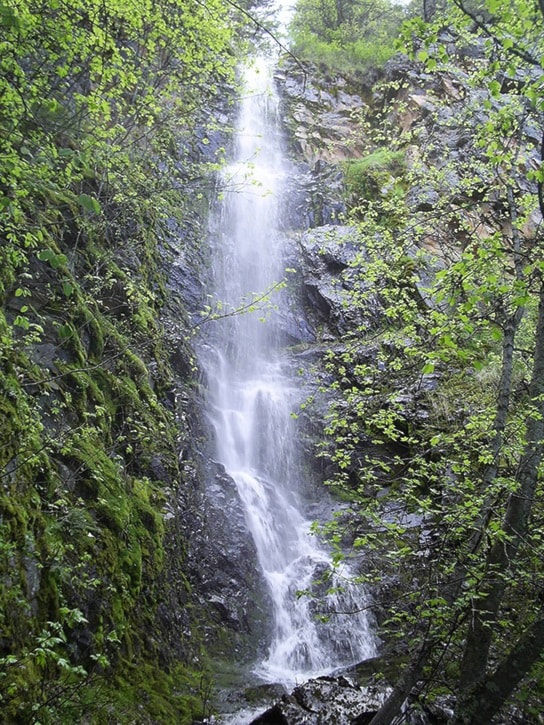
Back on the trail, after leaving the swamp the trail passes along a brook where I encountered three-foot fairy bells, spent trilliums, not-so-old glacier lilies and bronze bells. After one and half hours, I reached Holly Falls Trail but not after seeing the first bunches of freshly opened western blue clematis flowers and tiny blue flowers of blue-eyed Mary. On the short trail into the falls there were some fresh calypso orchids. Another I didn’t see down below, where early spring had passed, was twin-flowered honeysuckle (Google can help you with that one, too).
At 3:01, I reached a small lookout guarded by an unusually large ponderosa pine. Its diameter was at least four feet. Soon I reached an elevation where it seemed I was again back in April. There was an especially large patch of fresh glacier lilies, giving another encore of spring. Many other gems — landscape and scenery — were reencountered on this jaunt. A trek isn’t so hard when you get caught up in such beautiful surroundings!
See you on the Lady Slipper Trail!
(Last time we met, I mentioned that the elevation gain from Highway 3A to the Lakeview-Arrow Creek summit’s height-of-land on the Lakeview-Arrow Creek Road, was in the ballpark of 300-400 feet. Well, it is more like 600 feet.)
Ed McMackin is a biologist by profession but a naturalist and hiker by nature. He can be reached at 250-866-5747.