No matter how you do it, by foot, by bike or by car, it is up one side and down the other, by road or through the bush. The road route, over this height of land, however, probably gives a better feel for the idea of “divide” than the spot where the water runs either way, depending on whether the slope is to the west or to the east. At this point, the actual pass, a bit to the north, where one begins to go down one way or the other, is hardly detectable except to the observing eye. To some, anywhere in the bush is all the same. But the point on the road where one goes down to the west or down to the east is pretty obvious and to some much more dramatic, even traumatic, than the point in the forest where the waters divide. This little great divide is the height of land that divides the Lakeview district from the West Arrow Creek district and drainage.
Before the 1980s, there was no road like there is now joining Lakeview with Arrow Creek, making it possible to drive through from the Creston-to-Wynndel highway to the highway going to Kitchener. Here, instead of a Selkirk loop, one can experience a mini Purcell loop leaving Creston from the east or the north and, after passing through the Lakeview and West Arrow Creek communities, returning the other way. The route, roughly 28 kilometres from start to finish, passing through different landscapes, makes a nice loop, by bike or car or even by foot. I know of one party who did part of the loop on foot, except by following the power line and gas pipeline right-of-way around the backside of Arrow Mountain (a.k.a. Goat Mountain). It isn’t as easy as it appears to be. The north aspect of that mountain is very wet in some areas. And, because of that, it has a very interesting plant and animal community. Then, if you don’t like doing loops then you can hike from Erickson up over the top of Arrow Mountain and down to Arrow Creek.
The thought of passing through the route of the “little great divide” isn’t a recent one. Sometime around 1862, one of the routes of the Dewdney Trail from the Creston flats to the Goat River drainage east of Creston was pushed up over this height of land. In fact I can still see indications of the trail where the construction of the road in the 1980s obliterated the more obvious four-foot-wide section. I first became aware of it when a former resident of Foster Road pointed out the window and said, “It was right over there.” In the late 1940s and early 1950s they used to drive cattle over that portion of the Dewdney Trail, somewhat widened then, between Yahk and Wynndel, to and from grazing lands and from the trains out of Lethbridge.
In the choice and construction of any travel route, be it early trails or later roads, the easiest routes were followed, so we have trails, highways and railroads following the same valleys and slopes, the later highways largely obliterating previous routes. For the most part, the Dewdney Trail routing, where possible, tended to be on the south facing slopes where the snow would melt earlier, permitting earlier travel. Excepting the portion of the Dewdney Trail that passed easterly, where the road is now over the little great divide, the trail went generally along the north side of the Lakeview-Arrow Creek Road until the land flattens out. At the first left-hand turn proceeding west on Lakeview-Arrow Creek Road from Highway 3, the Dewdney Trail descended to a crossing of Arrow Creek and ascended over now private land through what is now East Arrow Creek.
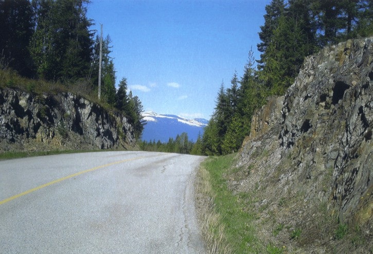
Biking west by road from Highway 3, involves a very gradual climb up to the divide, always making a left turn at major intersections. Travelling in the other direction, east, to stay on the main route one always turns right to get to Highway 3. Travelling the loop clockwise from north of Creston on Highway 3A, an extra breath or two will be required to get around those switchbacks up the Lakeview “hill”. When first doing it I found it easier when, as passing by, I took in the scenery rather than thinking about how far it was. After taking the first right of the main drag, the route flattens out and with one last little ascent reaches the divide where the Dewdney went over the rock instead of cutting through. The elevation gain from Highway 3A is in the ballpark of 400-500 feet. From there it is all downhill. But don’t be quite so quick. If you are walking or biking (not by car) stop in this rock cut and turn around and take in the view of the valley and the Selkirk Mountains on the other side.
This is the first rock cut. The second, farther east and down, is where the drainage went through a narrow define where, before the road construction, there were some cascading waterfalls. This spot was too rough and rocky for the Dewdney Trail. Before the road it was a place of reprieve and solitude in the shade of cedars and hemlocks where the sound of the brook was interspersed with the long trilling and warbling calls of winter wrens.
The cliffs created by rock blasting for the road have since rejuvenated. With almost 30 years behind them, these north facing defines have taken on a natural appearance with ledges and crevices harboring moist, mossy turf, little ferns, sapling shrubs and lichens. Kinnikinnick and trailing twinflower plants drape from the top.
Of course, there have been other changes too. Forty years ago, the little great divide and the West Arrow Creek valley were much different, with few people and stories that traced back to the 1930s: tales of ice jams, creek diversions, deep snows, prospecting, quartz cached in hollow stumps, settlers and cattle drives. Now, if you want a change from the world you are in now, in any season (but not in snowy conditions), take a walk, bike or car ride over the little divide. Here you are just to the south of where the water flows west down Lizzard Creek and to the Kootenay River or east into O’Kell Creek, Arrow Creek, Goat River and then the Kootenay River. Here, if coming from the west, at the little great divide, you enter a different world!
Ed McMackin is a biologist by profession but a naturalist and hiker by nature. He can be reached at 250-866-5747.