A couple of Sundays ago it seemed to be a good time to check out Holly Falls, which is accessed by a short trail about 3.2 kilometres up the Mount Creston Trail. We started out on the Balancing Rock Trail about mid-morning. The trail registry box was down, taken out by a large blowdown, a tree blown over by wind, which had been cut and moved off the trail. Many of the trees in this area are not deeply rooted because in many places there is only a thin layer of soil over the bedrock. Sometimes all it takes to bring a tree down, along with disease, is a gust of wind at the right time and place.
In places, the Balancing Rock Trail has become a bed for a little stream created by runoff from snowmelt. In many places where there is exposed bedrock, water has no other course than to run down the slope. In a couple of months the trail will be totally dry.
Past the big rock, we encountered snow, which was even more plentiful when we reached the ravine near the boardwalk that passes over the swamp. In contrast to the soft bare ground in the shelter of large evergreens, the open area at the swamp and boardwalk were covered with snow that in places was a foot deep. A few openings in the snow revealed a gurgling stream in an otherwise quiet scene.
The Rotary club members and friends have done an excellent job of making the boardwalk a solid structure again. They also added metal mesh, which makes the surface a lot safer to walk on when the boardwalk is quite slick from rain and autumn leaves.
For some reason or another there have been more than the usual number of opportunities this winter to observe the activities of pileated woodpeckers. The once three-foot hollow chiseled out of a grand fir by a pileated ("A closer look at dead and decaying trees") is now a 15-foot-high hollow. It reminds me of a dugout canoe, a hollowed-out log to make a boat. Soon after the boardwalk, we ran across several new woodpecker holes in some large cedar trees. The rectangular shape of the holes identified them as the work of a pileated. How they can detect the location of carpenter ants is quite amazing. A pileated’s hearing must be much better than mine, although I have no problem hearing the rumble of a pileated’s drumming on the dead top of a large cedar tree when I press my ear to the trunk. Large trees are not only good sound transmitters but also transfer heat upward from the ground in their trunks, thus making a warmer place for ants to “sleep” or be somewhat active, in their woody tunnels, during warmer times of the winter.
Our destination for this midday jaunt was to hike as far as the falls, although the trail continues on up Mount Creston to a rocky viewpoint about 4.5 km from the start of the Balancing Rock Trail. The stretch ahead of us from the cedar grove was more open terrain, so we were walking over up to a foot or so of hard packed snow. Earlier hikers and ungulates kept an open track through the snow.
Lots of stories were “told” along the trail. Obvious evidence of earlier wildlife presence were the many tracks of moose and elk. Now a four-legged animal makes a lot of tracks, double that of a human, so there may appear to be several moose. But there may have been only one moose along the trail browsing the tender last year’s growth from red-osier dogwood, buckbrush (red-stemmed coenothus) shrubs and mountain maples weighted down by snow. In one place, a moose bedded down right on the trail. That, along with all the droppings, indicated a moose had spent several days in the trail area.
Soon after the large birch grove, we came to the little ravine where the brook normally comes down from the falls and runs over the trail. However there was no water on the surface. With the fall rain we had and the relatively mild winter, I thought there would be some water in the brook as many other streams are open and running more than that of other years. Beyond this ravine are a few switchbacks and steep grades where the ice cleats and studded boots came in handy. It would have been quite unsafe without them.
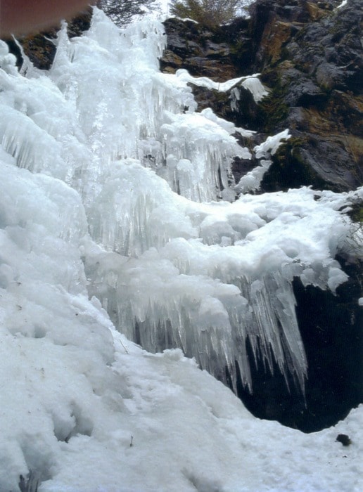
At about 3.2 km, on a bit of level, just before a viewpoint, mounted high up on a large evergreen on the left, a sign points out the trail, on the right, to the falls. In less than 10 minutes and several windfalls, we reached the falls, “frozen in time”. No wonder the little ravine below was dry. No water was coming over the falls but there were profuse amounts of icicles and ice bulges from bottom to top of this 100-foot column of solid, white ice. Holly Falls, without falling water, was magnificent! It may stay that way for a short time of near freezing temperatures.
Ed McMackin is a biologist by profession but a naturalist and hiker by nature. He can be reached at 250-866-5747.