Hot, dry weather remains in the weather forecast for the next few days, and Creston Valley residents shouldn’t expect any relief until there is rain, which could be coming on the weekend.
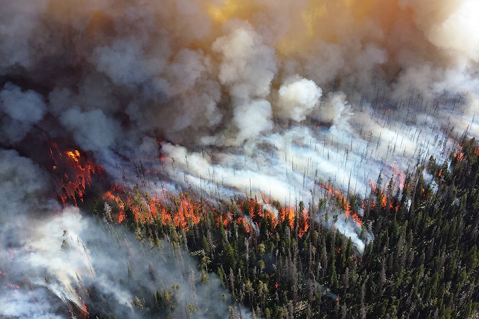
Fifteen “wildfires of note” were burning in the Southeast Fire Centre region as of Tuesday, and four for them, all caused by lightning, are contributing to heavy local smoke conditions. Other wildfires in Idaho, Montana, and Washington aren’t helping either.
On Tuesday, the federal government announced it was sending 200 military personnel and providing airplanes to help BC cope with the hundreds of fires now burning throughout the province.
The Southeast Fire Centre in Castlegar lists four fires that are affecting the Creston Valley and East Shore:
Blazed Creek: Approximately 2 km north of Highway 3 and 26 km northwest of Creston, discovered on August 7 and now covering an estimated 5,188 hectares.
Resources on site having been reduced two firefighters, one helicopter and five pieces of heavy equipment. Crews along with heavy equipment and air support are working to protect critical infrastructure.
Meachen Creek: In the Kianuko Provincial Park, approximately 25.5 kilometres southwest of St. Mary Lake, discovered on August 1.
The BC Wildfire Service has been actively monitoring this fire with flights twice daily as conditions allow. This fire has grown substantially in recent days due to it merging with another remote wildfire to the south (Mount Dickson); however, there has been little growth on this fire over the past 24 hours due to subsiding winds and cooler temperatures. By Tuesday morning it was estimated to cover 10,000 hectares but growth has slowed as winds have abated
This fire is producing heavy smoke, making obtaining an accurate map of the fire perimeter a challenge from the air.
To obtain an accurate perimeter map BC Wildfire Service will utilize an infrared scan of the fire. This information will help the BC Wildfire Service to continue to develop a strategy to achieve containment objectives. This fire is burning in steep, rocky and unsafe terrain for ground resources to respond at this time.
Though this fire is highly visible, at this time, it is still burning remotely. BC Wildfire Service number one priority is public safety and the safety of their crews.
An evacuation alert has been issued by the Regional District of East Kootenay in the St. Mary’s Lake area from the west boundary of the City of Kimberly to the Redding Creek/St. Mary’s River convergence including St. Mary’s Lake Road and Lakefront Road.
For more information on this alert, please call the RDEK at 250 426-2188 or visit their website at www.rdek.bc.ca
This fire is producing heavy smoke and residents of Kimberley and surrounding communities have been experiencing ash fall.
Crews are actively monitoring and planning for a response once the fire reaches more workable ground. This fire is remote; however, is very visible from surrounding communities.
McArthur Creek: Located in the Mount Waldie area, approximately 13 km southeast of Salmo and about 9 km east of Hwy. 6. Discovered on July 29, this wildfire now covers an estimated 206 hectares.
The Regional District of Central Kootenay (RDCK) has upgraded its evacuation alert to an evacuation order for the Sheep Creek Road area southeast of Salmo. For more information on this order please call the RDCK at 250 352-7701 or visit their website at www.rdck.ca.
This fire is located approximately 10 kilometres east of the (now over) Shambhala Music Festival and is surrounded by favourable geographic features that could act as natural fuel breaks.
This fire is a modified response fire meaning it is managed using a combination of suppression techniques, including direct and indirect attack, and monitoring to steer, contain and otherwise manage fire activity within pre-determined perimeters.
This fire is burning in remote terrain and is being closely monitored.
Discovered on August 11, this fire now covers an estimated 905 hectares.
Randal Creek: located approximately 17 km southeast of Yahk on the B.C./U.S.A. border.
The Regional District of East Kootenay (RDEK) has issued an evacuation alert for the Yahk, Meadow Creek Road and Highway 3/95 area. For more information on this alert, please call the RDEK at 250 426-2188 or visit their website at www.rdek.bc.ca.
11 firefighters and one helicopter continue to work on containment with the aid of air support.
The RDCK recommends the following steps to prepare when under an evacuation alert:
• Locate all family members or co-workers and designate a meeting place outside the evacuation area.
• Gather essential items such as medications, eyeglasses, valuable papers, immediate care needs for dependents, and keepsakes. Have them ready for quick departure.
• Prepare to move any disabled persons and/or children.
• Move pets and livestock to a safe area.
• Arrange transport. If assistance is required, call 250-352-7701.
• Arrange accommodation if possible. In the event of an evacuation, Reception Centres will be opened if required.
• Monitor new sources for information on evacuation orders and locations of Reception Centres.
Monitor the current status of BC Wildfires on-line at https://www2.gov.bc.ca/gov/content/safety/wildfire-status/wildfire-situation.