The Creston Museum is very pleased to be hosting an exhibit on the Columbia River Treaty this summer.
“The exhibit is provided by Columbia Basin Trust, which was created to benefit the areas most adversely affected by the Columbia River Treaty, and which has been taking an active lead as an information resource for Basin residents and local governments about the future of the treaty,” said Creston Museum manager Tammy Hardwick. “It’s a great opportunity to explore the history of the treaty — and the sheer size of the geographic region it impacts — and to understand a little bit more why it is so significant.
“We have a space in the museum that we have designated for community exhibits, a space where people and organisations can recognise their anniversaries, share their achievements and highlight significant events. And 2014 is a big year for the Columbia River Treaty.”
The Columbia River Treaty, which co-ordinates flood control and hydroelectric power production along the Kootenay and Columbia river systems on both sides of the Canada-U.S. border, was ratified in 1964. The earliest date the treaty can be unilaterally terminated by either Canada or the U.S. is 2024, if 10 years’ advance notice has been given — which means if either country wants to terminate the treaty, 2014 is the year to announce that intent.
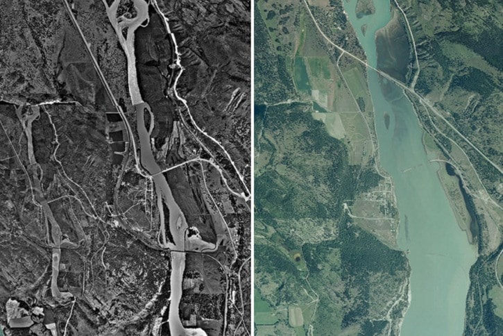
The Columbia River Treaty has had a huge impact on the Kootenays: the creation of entire lakes, the disappearance of whole communities, the availability of reliable electrical power, and even the types of agriculture practiced on the flats west of Creston — all of this, and more, are linked to the treaty.
And it has a long, long history.
“The issue of control of the Columbia River goes back to the late 1700s,” said Hardwick, “back to the days when rival fur-trading companies were racing each other to find water routes to the Pacific Ocean.”
In the 1850s, Britain and the U.S. very nearly went to war over who got the Columbia River, to the point where the British actually sent a couple of officers into the region, undercover, to find a route to bring in the whole British army if the need arose. That crisis was averted when war erupted down around the Alamo, encouraging the U.S. to settle the boundary at the 49th parallel to avoid a war on two fronts.
In the mid-1880s, William Adolph Baillie-Grohman planned to divert the Kootenay River into the headwaters of the Columbia River at Canal Flats, but the Canadian government put the kibosh on that scheme because it would mess up not one, but two international waterways.
The first few decades of the 1900s saw a number of attempts to reclaim the flats west of Creston and south into Idaho from the annual floods of the Kootenay River. There were discussions, at least, and a couple of partnerships spanning the border — a clear spirit of co-operation over shared management of the river.
The modern Columbia River Treaty has its roots in the flood of 1948, which was a disaster for the valley. Several near-floods since then — including one in 1961, when the only reason the Creston Valley didn’t suffer a flood was because the dikes south of the border in Idaho broke first — emphasised the need for international management of the two rivers.
Today, Libby Dam in the U.S., built as part of the treaty, has significantly reduced the risk of flooding on the flats west of Creston, but it has also contributed, in different ways, to increasingly erode the dikes that are still needed to prevent the floods.
Recently, both B.C. and the U.S. government have been reviewing the treaty. In December 2013, the U.S. entity made its final recommendations to the U.S. federal government for a modern treaty framework that balances power production, flood control and ecosystem function. In March, the province of B.C. announced its decision to continue the Columbia River Treaty and seek improvements within its existing framework.
“Columbia Basin Trust has vast amounts of information about the Treaty on their website (www.cbt.org/crt),” added Hardwick, “but this exhibit condenses it all and provides an easy overview — and links it all directly to the development of the Creston Valley.”
“The Columbia River Treaty” will remain open until Sept. 13. Admission is included in regular admission rates, or the exhibit alone can be viewed by donation.
For more information about the exhibit and the museum’s operating hours, please contact the museum at crestonmuseum@telus.net or 250-428-9262.
—CRESTON MUSEUM