Last week, we took a walk on the Balancing Rock, Creston Mountain and Fern Forest trails to gather some additional details on them and on their surroundings. These trails come together at a swamp and are joined together by a boardwalk that, two years ago, was in pretty bad shape. I discovered, to my delight, that the boardwalk upgrade was completed with new planks and steel mesh to reduce the slippery conditions on it when wet. Thanks to the Rotarians and friends for this improvement and repair completed in August.
Access over the swamp, provided by the boardwalk, offers an experience not available on any of the other popular trails easily accessed from Creston. Skunk cabbage plants with their bright yellow spathes, lady ferns with their six-foot fronds and devil’s club, with that “don’t touch me” look are, in season, easily viewed close at hand from the boardwalk. The predominate graceful lady ferns give one the experience of being in a verdant southern everglade, minus, of course, the crocodiles, or is it alligators?
The swamp and the boardwalk may be accessed over two trails: the Balancing Rock Trail and the Fern Forest Trail. Both provide moderate hiking access to the Creston Mountain Trail that continues up the lower slopes of Creston Mountain to a prominent viewpoint above the Wildlife Interpretation Centre. (The following distances are approximate and the times variable depending on hiking speed.)
The Balancing Rock Trail takes off to the right, west of West Creston Road at a pullout just a few hundred meters south of Highway 3, 10 kilometres west of the highways 3 and 3A junction on the north side of Creston. The “balancing rock”, a glacial erratic, a predominate feature of this trail, is 1.4 kilometres (0.86 miles) in trail distance from the trailhead. Elevation gain is about 860 feet. The trail reaches the swamp in 1.5 kilometres (0.9 miles). Shortly before reaching the balancing rock, there is a bench under a pine tree and just a few feet beyond, the trail makes an easily missed hard right to the north. Hiking time to the rock would be, more or less, a half-hour, and to the swamp about 45 minutes. At the bench one gets a panoramic view of the marshes, the winding Kootenay River and communities of Wynndel and Creston far to the east. Shortly beyond the rock, keep left.
The Fern Forest Trail takes off from the south side of the Highway 3 bridge over Summit Creek 11 kilometres west of Creston and one kilometre west of West Creston Road. Trail users need to park at the pullout just east of the bridge and walk to the trailhead on the south side of the bridge. Elevation gain is about 860 feet, the length is about 1.6 kilometres (one mile) and time is 45 minutes. After ascending through a dense evergreen forest to the height of land, the trail passes through an open forest of coniferous and deciduous trees, crosses an old road and then descends somewhat to follow along the swamp until it reaches the boardwalk and junction with the Balancing Rock and Creston Mountain trails. The swamp-side portion can be a bit soggy in early summer. At the registry box, a short distance up the trail, the Trans Canada Trail branches downward to the right and continues west for several kilometres above and along the south side of Summit Creek, crossing a logging road and continuing through a damp coast-like forest with huge moss-covered boulders, rock walls and cascading streams.
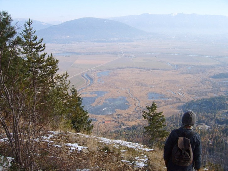
The hike up Creston Mountain to the rock overlook, starting from the Balancing Rock trailhead at West Creston Road and continuing on the Creston Mountain Trail, for the average hiker would be rated as a two-hour hike. The overall distance is about 0.4 kilomtetres (0.23 miles) and elevation gain is around 2,100 feet at about 3,900 feet elevation above sea level. From the overlook, just past the “End of Trail” sign, this elevation of nearly 4,000 feet gives a fantastic view of the Kootenay River valley. Far below, one can pick out the red roof of the Wildlife Interpretation Centre and the mosaic patterns in the ponds and marshes and farmer’s fields. In spring, the valley is carpeted in verdant green but the view is fantastic any time of year.
The Creston Mountain Trail reaches the top after several series of switchbacks spread out along its route. Some of the trail is quite steep and passes near some cliffs and steep inclines, requiring strict vigilance of trail conditions, location and hiker discretion.
After reaching the first overlook, the route heads shortly into a birch grove, which in summer provides dappled shade that extends about 1,000 feet along the mountain slope. From one of the overlooks, in spring, one can view a mass of white flowers in the tops of Virginia cherry trees. Further along, the trail enters a shallow ravine where in spring and early summer a small brook descends the trail a short distance before it flows down the slope. This watercourse is an indication that the junction to the Holly Falls Trail is coming up in about 15 minutes. The Holly Falls Trail takes off to the right on a bit of a level stretch. On the left, high on a large evergreen tree, is a white sign indicating “The Falls”. Just beyond this junction, the Creston Mountain Trail passes by another overlook at the top of a cliff.
 The Holly Falls Trail, approximately 200 meters in length, enters a rocky alcove where a stream splashes off the rock above, dropping about 30 metres. The rocks are covered with rich damp moss and are very slippery. One may find the area by the falls even too cool on a summer’s day. In winter, the falls is often a frozen column, draped with long icicles. In summer, the falls may dry up and not run again until there are some good rainfalls. Holly Falls has been named after a plant growing in the area.
The Creston Mountain Trail ends at a rocky lookout with a captivating view of the Kootenay River valley, the marshes, farmland and the communities of Wynndel and Creston.
To those of you for whom hiking is a new thing and, actually, to all hikers, I would say you will find that these trails, like most others, are not like city sidewalks. And the weather may be a bit more severe than what you are used to. Some of the trails may have water running down them and from late fall through spring this may have frozen and made the trail, in spots, very slippery. So, wherever or whenever you hike or walk, be sure and go equipped with extra jacket, gloves and even ice grips, and, of course, nourishing food and water.
Ed McMackin is a biologist by profession but a naturalist and hiker by nature. He can be reached at 250-866-5747.